When Water Becomes the Only Road in Monsoon Villages
Some villages don’t wait for roads to be fixed when the rains arrive. They simply pick up oars and keep going. Every monsoon, rivers quietly take over the job of streets, paths, and shortcuts.
When movement changes direction
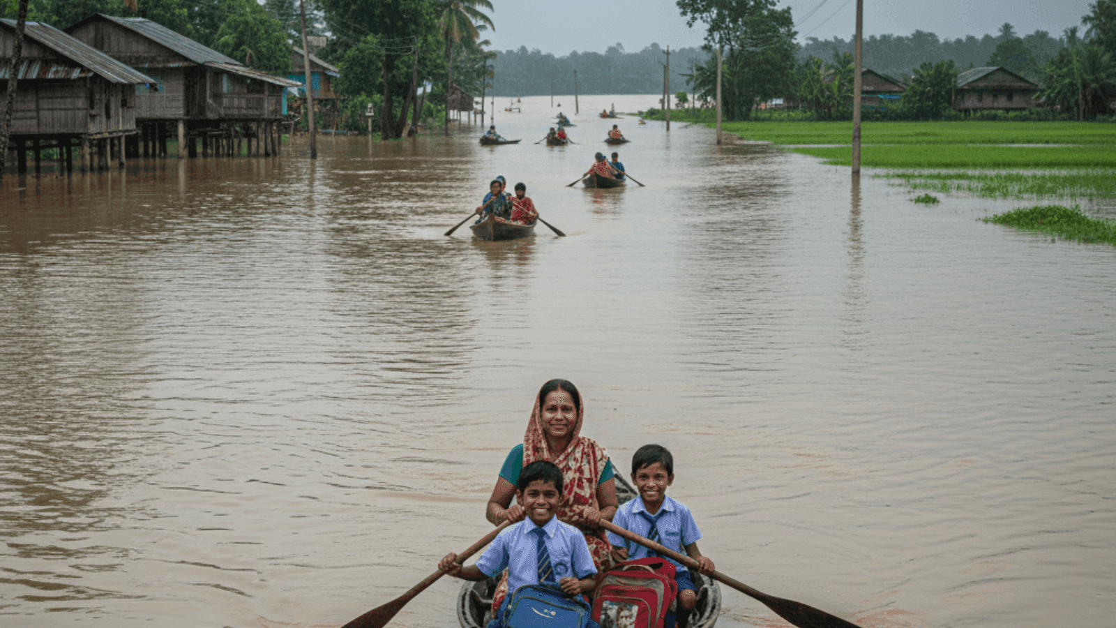
By the second week of June, the lane outside Sukati Puta village is no longer walked on. It is crossed. Oars dip where footsteps once were. Children balance school bags on their laps while a neighbour rows them across. The water does not arrive suddenly. It rises steadily, quietly deciding how the day will move.
Places where rivers turn into everyday routes
This way of living appears across specific flood-prone pockets of eastern India, especially where rivers widen and slow during the monsoon.
In Assam
In Assam, districts such as Morigaon, Jorhat, Golaghat, Dhubri, and low-lying neighbourhoods of Guwahati experience weeks of standing water every year. Villages located near the Brahmaputra and its tributaries like the Kopili and Doyang see roads merge into the river system. In places like Sukati Puta, Majorsapori, and Nikori, boats become the primary way to reach schools, markets, and workplaces once the rains settle in.
In West Bengal
In southern and central parts of West Bengal, villages along the Damodar, Ajay, and Rupnarayan rivers experience similar seasonal shifts. When canals overflow and embankments are overtopped, narrow rural roads disappear under slow-moving water.
Movement continues, but only through boats and makeshift rafts.
The Geography that allows this to happen
The geography of these regions makes seasonal flooding a recurring pattern rather than an exception. Rivers like the Brahmaputra originate in steep, elevated terrain. During intense rainfall, water rushes downhill into the plains, carrying large volumes of silt. Over time, this sediment raises riverbeds, reducing their capacity to hold water.
Even moderate rain can then spread outward, covering roads, fields, and courtyards.

Rain that arrives differently now
While overall monsoon rainfall in the Northeast has declined over the last few decades, short and intense spells of rain have increased. Water enters low-lying areas faster than it can drain away. Once submerged, these areas remain waterlogged for weeks.
How daily life adjusts on water
When roads vanish, routines rearrange themselves. In early June this year, residents in Morigaon district and parts of Guwahati began rowing to school and work. Rubber boats, once kept only for emergencies, are now used daily.
Children sit still to keep balance. Adults memorise new routes between electric poles and rooftops. Timing matters. Currents change by the hour.
Boats as shared resources
Many families save specifically to buy small rubber boats. In some neighbourhoods, one boat serves several households. Repairs are constant. Punctures are patched and reused. Disaster-grade boats introduced by the state, including Japan-assisted models, are mainly used during rescue operations. Everyday movement depends on what residents can afford themselves.
Living beside embankments year-round
- In parts of Jorhat district, families displaced by river erosion now live permanently on embankments built to hold back floodwaters.
- Majorsapori village is one such settlement where entire households have shifted after losing farmland to recurring floods.
- During heavy rain, even the embankment sits close to water level, leaving little stable ground.
- Everyday activities like cooking, sleeping, and storing belongings change location repeatedly as water rises and recedes.
Farming cycles during floods
In Golaghat district’s Nikori village, paddy fields are replanted multiple times a year. Farmer Umanada Pathori grows boro rice because crops often do not survive long stretches. This year, water released from the Doyang Hydro Electric Project increased water levels downstream, affecting nearly 1.8 acres of his land in early June.
Each flood redraws the agricultural calendar.
Systems that now work alongside water
Early warning systems are being installed in villages downstream of dams to alert residents before water is released. Studies are underway to understand how dam operations influence downstream settlements.
Relief camps operate during peak floods, while dry rations are provided to those who stay back on embankments or in partially flooded homes. From there, boats remain the main link between homes and the outside world.
Learning the river as a route
Children grow up judging water depth by colour. Adults sense current strength through sound and movement. Routes change weekly. What works today may not work tomorrow. When the monsoon settles in, the river does not interrupt life. It carries it forward.
If places like these make you curious about how people live with water instead of fighting it, Neomaxer helps you stay close to stories rooted in real regions and rhythms.